PLOTTING


Plotting
your
position
is
vital
and
this
selection
of
common
solutions
will
provide
basic
knowledge on what you could do.


INFLUENCES
Whilst
plotting
your
position
it
is
necessary
to
consider
certain
issues
that
could
affect
the
accuracy
of the final result.
These
influences
may
involve
some
of
the
following
areas shown here in no particular order:
Methodology
Using
the
best
and
most
appropriate
way
of
conducting a position fix.
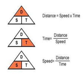
Distance / Speed / Time
Using
the
DST
triangle
to
ensure
making
the
correct
calculations
Magnetic to True / True to Magnetic
Know
the
recommended
methodology
to
take
into
account these variables in your calculations.
Variation
Take
the
variation
values
from
the
nearest
chart
Rose to ensure accuracy.
Deviation
Ensure
all
factors
have
been
considered
before
applying
the
variable.
Using
a
table
or
checking
your
position
when
taking
the
bearing
for
any
external
influence.
Tide Atlas / Tidal Diamonds
Reference
to
both
sources
of
information
will
help
ensure factoring in this major influence.
Set and Drift
Easy
to
apply
in
the
wrong
direction
som
double
checking
is
helpful
to
ensure
course
to
steer
is
correct.
D S T
Speed, distance, time
It
is
very
important
to
be
aware
of
the
units
being
used when calculating speed, distance and time.
Sometimes
you
will
need
to
convert
a
measure
into
different units. For navigation the Units must be;
Distance: Nautical miles
Time: Minutes
Speed: Knots
Note
that
’Speed’
is
a
‘compound
measure’
and
therefore
involves
two
units;
a
combination
of
a
distance in relation to a time.
When
you
use
the
speed
distance
/
time
formula
you
must
check
that
each
measure
is
in
the
appropriate
unit before you carry out the calculation.
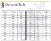
DEVIATION
Compass
deviation
is
another
magnetic
error
effecting
the
steering
compass.
Variation
is
a
magnetic
interference common to all vessels.
Deviation
is
a
magnetic
interference
unique
to
the
vessel itself.
This
can
be
from
things
such
as
batteries,
large
metal
objects like the engine, speakers, VHF radios etc.
The
overall
effect
of
the
vessel's
deviation
can
be
calculated.
It
is
recorded
on
something
called
a
deviation card.
It
is
important
that
you
carry
out
the
calculations
in
the correct order.
The
image
can
remind
you
of
the
steps
in
the
correct
order or use the mnemonic;
Cadburys Dairy Milk Very Tasty
C
ompass heading make a
D
eviation correction, to give a
M
agnetic heading to adjust with
V
ariation to get a
T
rue heading.


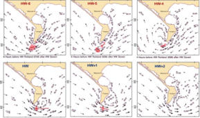
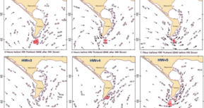
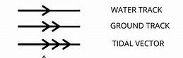
TIDAL ATLAS
A tidal
atlas or
a tidal
stream
atlas is
used
to
predict
the direction and speed of tidal currents.
A tidal
atlas usually
consists
of
a
set
of
12
or
13
diagrams,
one
for
each
hour
of
the
tidal
cycle,
for
a
coastal region.
Mark
page
for
High
tide
with
the
time
given
for
hight
tide
on
that
day
and
on
subsequent
pages
before
and
after
the
high
tide
page
write
the
time
taking
plus
or
minus one hour accordingly.
Each
diagram
uses
arrows
to
indicate
the
direction
of
the flow at that time.
The
speed
of
the
flow
is
shown
by
the
length
and
thickness
of
the
arrows,
for
all
except
the
smallest
arrows
where
numbers
give
more
precise
information.
SET & DRIFT
Set
and
drift
navigation
is
a
crucial
method
for
determining
a
vessel's
actual
position
by
accounting
for
external
forces
like
currents
and
winds
that
affect
its intended course.
Understanding Set and Drift
Set
refers
to
the
direction
of
the
current
or
wind
that
affects
the
vessel's
movement,
expressed
in
true
degrees.
It
indicates
where
the
current
is
pushing
the
vessel off its intended path.
Drift
is
the
speed
of
the
current,
typically
measured
in
knots,
which
represents
how
fast
the
vessel
is
being pushed off course by these external forces.
Importance in Navigation
Ignoring
set
and
drift
can
lead
to
significant
deviations
from
the
intended
course,
sometimes
resulting
in
a
vessel
being
off
course
by
hundreds
of
miles.
Therefore,
navigators
must
understand
and
compensate
for
these
factors
to
maintain
their
desired route.
In
order
to
utilize
set
and
drift
in
navigation,
navigators
must
first
set
the
course
using
Dead
Reckoning.
If
there
is
a
known
set
and
drift,
then
the
corrections
can
be
applied
to
the
Dead
Reckoning
position to then get an Estimated Position on a chart
METHODS
For
reliability,
we
must
endeavour
to
use
methods
that
are
best
suited
and
most
accurate
to
obtain
a
correct fix. These are some of the options available.
FIX:
A
position
derived
from
a
known
external
reference
point along a known position line.
CHARTED OBJECT
Easiest
ways
to
fix
your
position
using
known
marker
e.g. buoy alongside vessel.
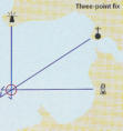
THREE POINT FIX
Bearings
off
three
known
points,
angles
over
120
degrees provide smaller ‘cocked hat’.
TWO POINT FIX
Bearings
off
two
known
points,
angles
best
to
be
more than 90 degrees for accuracy.
SOUNDING, CROSSED WITH BEARING
Using
depth
contour
line
being
crossed
on
a
known
bearing.
CROSSED TRANSIT
When
two
known
objects
are
in
line
and
bearing
from another fixed known object
SINGLE TRANSIT
When
two
known
objects
are
in
line,
only
shows
you
somewhere along that line.
SINGLE BEARING
Limited
value
as
position
line
(LOP)
only
shows
you
somewhere along that line.
RUNNING FIX
Two
or
more
bearings
from
one
fixed
mark
along
a
position lines, relatively accurate position.
ESTIMATED POSITION
Taking
into
consideration
possible
effects
from
wind,
tide set and drift.
DEAD RECKONING
One’s
current
position
is
calculated
based
on
/
using
a previously obtained position.
RADAR:VRM & EBL
VRM:
Using
two
ranges
drawn
onto
chart
that
intersect.
EBL:
Using
one
range
marker
and
one
electronic bearing line to intersect.
VARIATION
True
North
is
at
the
centre
of
the
north
pole.
A
fixed
point at the top of the planet.
Our
navigational
charts
are
orientated
so
that
they
use
true
north
as
their
reference
point.
This
is
because true north doesn’t move.
Compass
magnets
don’t
point
towards
true
North,
however.
They
point
toward
magnetic
north
which
is
in a different geographical place.
The
difference
in
the
angle
between
true
north
and
magnetic north is call Variation.
You
can
only
plot
true
headings
on
navigational
charts
so
magnetic
compass
bearings
have
to
be
converted to True bearings before plotting.
The
mnemonic
CADET
can
help
reminds
us
that
if
we
are
making
an
alteration
from
a
compass
heading
to
a true heading, we add easterly variation.

From
C
ompass
A
dd
E
ast
T
rue
TIDAL DIAMOND
These
are
symbols
on
British admiralty
charts and
others
that
indicate
the
direction
and
speed
of tidal
streams.
The symbols consist of a letter printed in purple ink.
On
any
chart
each
tidal
diamond
will
have
a
unique
letter starting from "A" and continuing alphabetically.
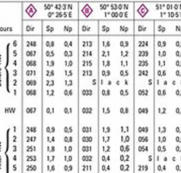


The
columns
show
the bearing of
the
tidal
stream
and
its
speed,
in knots,
at
both spring
tide and neap
tide.
This
contains
a
grid
of
thirteen
rows
and
three
columns for each Diamond.
The
rows
are
the
hours
of
the
tidal
cycle
showing
the
6
hours
before high
water,
high
water
itself
and
the
6 hours after high water.
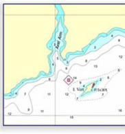
POSITION FIX
Before
going
to
sea,
a
course
is
plotted
on
a
chart
noting
bearings,
distances
and
expected
times
for
each leg of the trip.
While at sea, position is fixed at regular intervals and
the
course
adjusted
when
necessary.
This
is
safe,
sensible practice.
It
is
a
'general
safety
obligation'
of
the
person
in
control
of
the
vessel
and
applies
to
both
large
ships
and smaller recreational craft.
A
position
fix
is
marked
on
the
chart
only
when
it
is
known
as
a
correct
position.
The
position
may
be
given
in
Latitude
and
Longitude
which
can
then
be
marked
using
for
Latitude
the
vertical
scale
on
either
side
of
the
chart
NEVER
the
scales
shown
at
the
top
or bottom.
Known
marks
like
buoys,
light
vessels
etc
are
good
sources
to
make
a
position
fix
from
which
further
fixes can be made.
.
A
fix
from
a
GPS
navigation
aid
can
be
very
useful
to
plot
either
to
start
the
passage
or
check
other
data
used.


Position fix symbol
GPS Position fix symbol
Position fix symbol
CHARTED OBJECT
One
of
the
easiest
ways
to
fix
your
position
is
to
sail
up alongside a charted object.
Buoys
are
the
obvious
choice,
but
remember
that
they
can
be
relocated,
especially
in
areas
of
shifting
sand or mud banks.
Keep
your
charts
up
to
date,
and
where
possible
choose an object firmly fixed to the seabed.
Grab
your
chart,
make
a
cross
next
to
the
object,
note the time and log reading, and you’re done.
Dead
Reckoning
(DR)
Position
is
the
position
of
the
ship
solely
based
on
its
last
known
position,
course,
and
speed
over
a
given
period
without
taking
into
account
external
factors
such
as
wind,
current,
or
other navigational influences.
A
previously
determined
position
can
also
be
termed
as
a
fix; the
estimated
speed
and
the
course
are
applied to that fix to obtain a DR.
A
DR
position
should
be
made
every
time
when
there
is
a
change
in
course
and/or
speed,
the
DR
position
must be plotted afresh.
If
the
predicted
course
line
is
judged
to
be/proofed
to
be
incorrect,
plot
the
DR
once
again
for
the
corrected
data.
Do
not
draw
a
new
course
line
from
an
Estimated
Position (EP).
Always plot a new course line from a fix
DEAD RECKONING
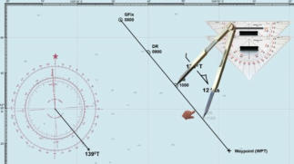
RUNNING FIX
The
Running
fix
is
not
particularly
accurate,
but
provides a useful fix if landmarks are scarce.
If
there’s
only
one
suitable
charted
object
in
sight,
and
you
can’t
determine
your
range
using
a
depth
contour,
given
time
you
can
find
your
position
using
a running fix.
This
is
often
the
case
at
night,
when
your
choice
of
objects
from
which
to
take
bearings
are
limited
to
those that are lit.
This
method
is
most
appropriate
when
your
voyage
is
more or less parallel to the coast.
There
is
a
need
to
follow
the
procedure
for
this
fix
carefully to ensure the best outcome.
ESTIMATED POSITION
Estimated
positions
are
essential
for
maintaining
a
record
of
a
vessel's
progress,
especially
during
long
passages when visual references may be limited.
By
plotting
estimated
positions
regularly,
navigators
can
ensure
they
remain
on
course
and
avoid
hazards,
particularly
in
challenging
conditions
or
when
visibility is poor.
In
summary,
understanding
and
accurately
calculating
an
estimated
position
is
vital
for
effective
navigation,
allowing
mariners
to
make
informed
decisions about their course and safety at sea.
It
is
determined
using
the
vessel's
last
known
position
and
accounting
for
various
factors
that
may
affect its movement, such as:
Course Steered:
The direction in which the vessel is heading.
Speed of the Vessel:
How fast the vessel is moving.
Time Elapsed:
The
duration
since
the
last
known
position
was
recorded.
External Influences:
Factors
like
wind
(leeway)
and
tidal
currents
that
can
cause the vessel to drift from its intended course
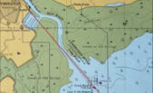
TRANSITS
Transits
are
formed
when
two
charted
objects
are
in
line.
They
are
often
found
marked
on
charts,
or
in
pilot
books,
to
give
a
clearance from a danger or a safe entrance into port.
Transit: Single
This
provides
an
accurate
line
of
position
and
gets
you
halfway
to
an
accurate
fix
–
you
just
need
to
find
where
you
are
on
the
line.
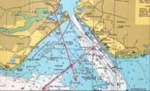
Transit: Crossed
The
best
way
to
find
your
position
on
a
transit
is
to
find
another
one
which
crosses
it,
ideally
at
about
90°.
This
is
a
tremendously
accurate
way
to
fix
your
position,
but
you
generally
need
to
plan
the
fix
beforehand,
so
it’s
often
used
to
give an accurate fix for starting a passage.
The
easiest
way
is
to
find
charted
transits,
or
objects
on
the
chart
which
form
suitable
transits.
Then,
to
get
to
the
planned
position,
pick
up
one
of
the
transits
and
sail
along
it
until
the
other transit marks come into line.
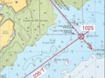
Transit: With bearing
A
river
entrance
transit
crossed
with
a
bearing
at
roughly
90°.
In
the
absence
of
another
transit,
a
bearing
on
a
fixed
object
provides
a
good
fix.
Always
try
to
choose
an
object
which
lies
at
roughly
90°
to
the
transit
–
shallow
angles
of
intersection
create
greater errors.
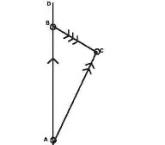
BEARINGS
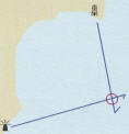
Plot
your
first
position
line,
this
is
the
first
bearing
to
our
known
reference
object.
We
are
somewhere
on
this
line,
but
do
not
know where.
Plot
our
second
position
line
after
a
period
of
run
time,
during
which
we
have
ideally
passed
the
abeam
of
the
known
object,
we
take
and
plot
a
second
position
line
to
the
same
object.
We
are now somewhere on this line.
Two
or
more
intersections
among
position
lines
give
us
a
relatively accurate position of the vessel.
The
optimum
angle
of
intersection
between
two
position
lines
is
90 degrees
Fix: 3 points
When
choosing
three
charted
objects,
maximising
the
angles
between
them
to
minimise
error.
Lighthouses
and
buildings
are
the
ideal
choice
as
they
don’t
move
and
are
easy
to
sight
through the compass.
Take
bearings
as
quickly
as
possible,
noting
them
down
as
you
go
and
leaving
the
one
most
abeam
until
last
–
this
bearing
changes the fastest.
Then
plot
them
on
the
chart.
Unless
you
have
a
stationary
boat
and
extraordinarily
steady
hands
the
lines
will
not
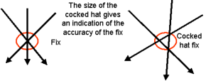
intersect
perfectly,
instead
coming
together
in
a
triangle
called
a
‘cocked
hat’.
Your
true
position
could
be
anywhere
within
this
triangle,
so
the
smaller it is, the more accurate your fix.
RADAR
All
radars
are
equipped
with
a
variable
range
marker
(VRM)
and
an electronic bearing line (EBL).
These
allow
you
to
obtain
an
accurate
fix
from
a
single
object.
Placing
the
electronic
bearing
line
on
an
object
will
give
you
its
bearing,
relative
to
the
ship’s
head,
and
the
VRM
will
give
its
range.
By
adding
or
subtracting
the
bearing
from
the
compass
course,
depending
on
whether
to
object
is
to
starboard
or
port,
and
correcting
for
deviation
and
variation
of
the
ship’s
compass,
the
bearing
can
be
drawn
on
the
chart
and
intersected
with
the
range to give an accurate position by day or night.
Intersecting
ranges
give
two
positions,
but
it’s
usually
clear
which one is valid.
Another
way
to
obtain
your
position
by
radar
is
to
use
the
Variable
Range
Marker
to
find
the
range
of
two
objects
(Racons
are
ideal).
This
avoids
any
calculation
at
all:
simply
find
the
two
ranges
and
draw
them
on
the
chart
with
a
pair
of
compasses,
using the charted object as the centre.
The
resulting
circles
will
intersect
in
two
places,
giving
two
possible
positions.
However,
it’s
usually
obvious
which
is
correct
–
the
false
one
is
often
on
land!
If
there
is
any
doubt,
a
rough
bearing will clear up the ambiguity.
ECHO SOUNDER
A
depth
contour
may
be
the
first
useful
position
line
available when making landfall.
The
echo-sounder
has
of
late
become
simply
a
tool
to
prevent
you
running
aground,
but
in
conjunction
with
the
chart
it
can
be
a
useful
source
of
position
information.
To
use
the
echo-sounder
for
position,
you
need
to
know the current height of tide.
It
is
clear
on
the
chart
contour
lines
to
show
various
depths
which
you
will
cross
Checking
when
you
go
over
such
a
contour
line
and
having
a
bearing
on
a
known object that will plot your position.

- MVS
- Maritime Studies
- Able Volunteer
- Foundation
- Induction
- Introduction
- Leading Volunteer
- Role of LV
- Collision Regs 11 - 31
- Rule 11 - Vessels insight
- Rule 12 - Sailing vessels
- Rule 13 - Overtaking
- Rule 14 - Head on
- Rule 15 - Crossing
- Rule 16 - Give way
- Rule 17 - Stand-on
- Rule 18 - Precedence
- Rule 19 - Restricted visibility
- Rule 20 - Application
- Rule 21 - Definition Lights
- Rule 22 - Visibility - Lights
- Rule 23 / 31 - Lights & Shapes
- Rule 32 / 37 - Sound & Lights
- Navigation Part 2
- Pathway
- MVS
- Introduction
- Induction
- Foundation
- Able Volunteer
- Leading Volunteer
- Detail
- Role of LV
- Collision Regs 11 - 31
- Detail
- Rule 11 - Vessels insight
- Rule 12 - Sailing vessels
- Rule 13 - Overtaking
- Rule 14 - Head on
- Rule 15 - Crossing
- Rule 16 - Give way
- Rule 17 - Stand-on
- Rule 18 - Precedence
- Rule 19 - Restricted visibility
- Rule 20 - Application
- Rule 21 - Definition Lights
- Rule 22 - Visibility - Lights
- Rule 23 / 31 - Lights & Shapes
- Rule 32 / 37 - Sound & Lights
- Navigation Part 2